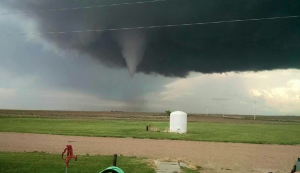
Tornado at 6:00 p.m. on Wednesday photo taken at Road 120 and HH, courtesy of Rodney Kelling and Haskell County Emergency Management
GARDEN CITY, Kan. – Another round of severe weather rolled across Kansas on Wednesday evening.
The storm brought heavy rain to many areas of the state. Southwest Kansas also saw funnel clouds, hail and strong winds.
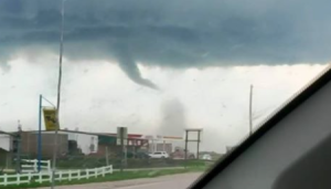
The storms produced several mostly short-lived tornadoes in Logan, Lane, Haskell, Finney and Hodgeman counties, causing damage to trees, power poles and outbuildings.
Five to six inches of rain fell Wednesday and overnight in Lane, Finney, Hodgeman, Haskell and Meade counties.There are no reports of injuries.
Finney County officials reported flooding over the road near Kalvesta but no damage.
The Hodgeman County Sheriff also reported some minor flooding in the western part of the county.

View of the funnel cloud from the U.S. 83/56 junction. Photo courtesy of Haskell County Deputy Eric Lalicker.
Many areas of the state are under flash flood watches and warnings. Additional rain and possible thunderstorms are in the forecast through Friday.